Free Online Tools To Inspect Your Property
Are you interested in learning more about your property? There are a number of free online tools that can help you evaluate the exterior of your home, yard, and neighborhood. With a little online detective work, you can learn quite a bit about a property that can help you plan a project, fix a problem, or see see how your property has changed over time.
The information available from the free online tools will depend on the location of your property. The best way to find out what's available for your property is to give them a try. Here's how to do it.
Go Back In Time
Google Street View and Bing Maps Streetside
The Street View feature in Google Maps allows you to get a look at your property as it is viewed from the street. Since its launching back in 2007 Google has been methodically cataloging cities of the world. This massive effort takes time meaning the images are dated - literally. If you take a look at your property with Google Street View (PC only), you will find the image capture date shown at the bottom of the screen. Similarly, Microsoft's Bing Maps Streetside feature can provide a dated street perspective of your property. Not every street and home are covered in Google Street View or Bing's Streetside so you'll have to enter your address and see if one or the other is available.
Here's an example of going back in time by looking at the Carter G. Woodson Home National Historic Site in the District of Columbia (1538 9th St NW, Washington, DC 20001). The Google Street View image is only about a year old and shows an updated an well-maintained street. The Bing Streetside image is about five years older and shows a somewhat neglected street that is under development. So go ahead, type your address into these tools and travel back in time!
Carter G. Woodson Home National Historic Site - Google Street View July 2019
Carter G. Woodson Home National Historic Site - Bing Streetside October 2014
Google Street View Archives
Google has been collecting and archiving Street View Images since 2007. Using the "clock" feature, you can get access to these archived images. The clock feature is not available for all Street View images. If your property is in a major city on a well-traveled street, your chances are better that the clock icon will show up in Street View. If you live in a area where Google has no archived images, the clock icon will be absent. Note: this feature is only available on the full version of Street View on your PC and is currently not available on your phone.
Google Street View Clock Icon for Image Archives
Here's a a look at the Carter G. Woodson Home National Historic home over time. This timelapse was created from the Google archived Street View images from 2007 to 2019.
Carter G. Woodson Home National Historic Site - 2007 To 2019 Timelapse Using Google Street View Archive
Google Earth Timelapse
Another tool to look back in time is Google's Earth Timelapse website. You won't be able to zoom in to see your property in detail but this tool allows you to see how a geographic area has changed over time. At the website, enter your property address in the search box. You will then see a progression of aerial views going back about 35 years. This is a great way to observe major changes to the area surrounding your property over time. You can step through the progression of images manually or let Google provide a timelapse for you.
Google Earth Timelapse Example - San Francisco California
GIS Maps
Geographic Information System (GIS) maps are the augmented reality maps of the map world. Basically these are standard maps with additional information layered on top. Initially developed for scientific research, GIS maps are now readily available online for free. The GIS maps in the US are typically generated by the counties in each state. So to find a GIS map for your property, just do a Google search for your county. For example, if you want to find the GIS map for Hempstead County Arkansas, type this:
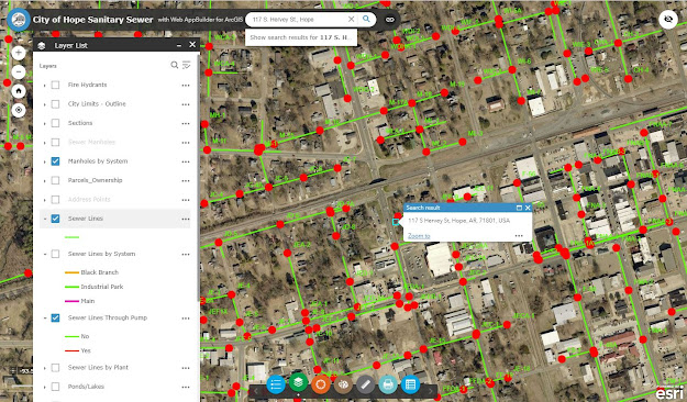
Here's a look at the area around President Bill Clinton's 1st Home Museum, a unit of the National Park System located at 117 S. Hervey St., Hope Arkansas. Shown here are several examples of GIS maps layers that can be clicked on or off.
Hempstead County GIS Map - Fire Hydrants
Hempstead County GIS Map - Railroads
Hempstead County GIS Map - Sewers and Manhole Covers
Monroe County Florida - Hurricane Irma Damage
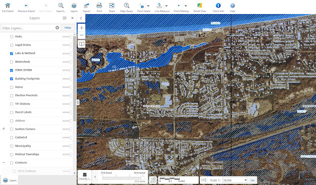
Another GIS map example for Lake County Indiana showing lake and wetland areas.
GIS map availability and features vary greatly by location. Some counties have no GIS maps and others have maps loaded with layers of information. If a GIS map is available for your county, check it out. These maps are a great way to get a wide area look of your neighborhood or city to reveal information ranging from political data to flood planes.
Measure Up!
Do you want to measure your yard or exterior house dimensions? No problem. Google Maps has a built-in measurement tool (PC only) that you can use. The measurements won't be as accurate as a plat of survey but they are free and easy to make. To make a measurement, go to Google Maps and switch to satellite view and zoom into your property. Then, right click with your mouse and select the "Measure Distance" feature. A single click on the map will drop down a couple white dot "handles" you can drag around the map to make a measurement. Click again to add one ore more additional measurement handles.
Right Click On Google Maps to Measure Distance (PC Only)
Example Distance Measurement - Lincoln Home
The Google Map measurement tool can come in handy to measure your property lot size, house dimensions, and spacing to neighbors or other landmarks.
Zoom In and Look Down
A lot can be learned from a zoomed in satellite view of your property. So punch in your address into Google or Bing Maps, switch to satellite view and zoom in to find....
- Landscaping - trees, bushes, lawn, etc.
- Hardscapes - driveways, patios, walks, retaining walls, stairs, etc.
- Fencing
- Proximity to... neighbors, stores, roads, creeks, businesses, etc.
- Size and shape of...house, yard, out buildings, etc.
- Roof features such as color, vents, chimneys, etc.
Also, you might want to check to see if your property is covered in a Bing Map bird's eye view. To check, go to a Bing Map area and right click, if you see the "View bird's eye" available, select that option and take a look.
How to Select Bird's Eye View in Bing Maps
The bird's eye view allows you to rotate the perspective map image to one of four orientations. This is a great way to find other details in your property that you may not be able to see in a "flat" satellite image.
Example of Bing Map's Birds Eye View - Clearwater Beach Florida
Similarly, you can check-out Google Earth to see if your property is covered with 3D perspective views. If it is, you'll be able to zoom in and rotate the view as desired. If 3D data is not available in your area, you'll still be able to zoom in and rotate but the image will appear "flat".
Tags
Tools


